
FinBee TAC: Tracking Growth Every Year Where It Matters Most

For county assessors, timing matters.
Growth does not wait three years. New construction does not wait five years. Additions, outbuildings, remodels, commercial improvements, and land-use changes can happen quickly. When imagery and assessment data are outdated, counties are left trying to make decisions with missing information.
That is where FinBee TAC comes in.
Many traditional imagery programs provide broad coverage, but updates may only happen every three to five years. That model can work for stable areas, but in growth areas, priority reappraisal zones, subdivisions, commercial corridors, and high-change communities, the data gap can create real problems.
Missed improvements can lead to incomplete assessment records, delayed tax roll updates, Board of Equalization challenges, and a lack of supporting visual evidence when questions arise. By the time the next broad imagery refresh arrives, multiple years of change may already be missing from the county’s records.
FinBee TAC takes a more practical approach: track change every year where it matters most.

A Smarter Use of the Same Imagery Budget
Many counties already spend significant money on imagery programs that may only refresh once or twice over a six-year period. While broad countywide coverage has value, that model can leave assessors without current data in the exact areas where growth and assessment changes are happening.
FinBee TAC offers a different approach.
For a similar overall investment, counties can focus annual acquisitions on growth areas, reappraisal priorities, and high-change corridors instead of waiting three to five years for the next broad refresh.
This allows counties to keep their most important assessment data current without needing to remap the entire county every year.
Instead of simply buying imagery, counties are investing in a repeatable assessment-support system that helps track growth, document change, support BOE questions, and give staff the data they need when they need it.
More Than Imagery: A Working Assessor System
Imagery by itself is useful, but imagery alone does not solve the full assessment problem.
Assessors need parcel context. They need measurable 3D information. They need change tracking. They need simple tools that staff can actually use. They need data that supports field review, valuation workflows, documentation, and defensibility.
FinBee TAC brings those pieces together.
Our system can include high-resolution orthomosaics, advanced 3D mesh data, parcel fabric overlays, accurate 3D measurement tools, AI-derived building layers, and web-based viewing tools designed around assessor workflows.
Parcel fabric overlays allow assessors to view imagery and 3D data directly in relation to parcel boundaries and assessment records. Instead of looking at imagery separate from the tax roll, staff can connect visual evidence to the actual parcels they are responsible for reviewing.
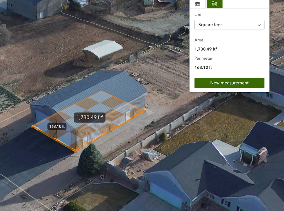
Advanced 3D measurements allow users to measure structures, rooflines, additions, and site improvements with a high level of accuracy. This supports office review, field verification, and documentation without requiring staff to visit every property in person.
The portal viewer is built for both simple and advanced use. Assessor staff can quickly review parcels, inspect 3D data, and make measurements without needing complex GIS workflows. GIS and technical users can also use the same data for deeper analysis, integration, and internal county operations.

AI Building Detection as a Visual Growth-Tracking System
FinBee TAC also offers AI-derived building detection layers that help assessors identify, review, and track improvements over time.
These layers can include building footprints and other extracted features that support parcel review and change detection. When combined with parcel fabric overlays, current imagery, and 3D models, AI building detection becomes more than an analytic layer. It becomes a visual growth-tracking system.
Instead of manually searching every parcel for possible changes, assessor offices can use AI-derived layers to help identify where new structures, additions, missing improvements, or altered building footprints may need review.
The value is not just detecting buildings.
The value is turning that detection into a practical workflow for tracking growth, prioritizing staff time, supporting tax roll updates, and improving consistency across the county.


Hosted Access or County-Owned Data
FinBee TAC gives counties flexibility in how they access and control their data.
Some counties may prefer hosted access through a simple web-based portal. Others may want owned data that can be brought into their own GIS environment and managed internally.
Both options have value.
The hosted option gives counties a simple way to access powerful assessment tools without needing to build everything themselves. The ownership option gives counties long-term control over their geospatial assets, historical records, and internal workflows.
That matters because assessment data is not just a temporary viewing product. It is part of the county’s long-term record, decision-making process, and tax assessment foundation and Esri based to boot.
Built Around the Work Assessors Actually Do
FinBee TAC’s goal is not simply to sell imagery.
Our goal is to support a better tax assessment system.
By combining annual change tracking, high-resolution imagery, advanced 3D measurements, parcel fabric overlays, AI-derived building detection, hosted viewer options, and county-owned data options, FinBee TAC gives assessors a more complete system for managing growth and supporting fair taxation.
Counties need current data where it matters. They need tools that staff can use. They need control over their information. And they need a system that supports the real work of assessment.
That is where FinBee TAC provides value.
We help counties see change, track growth, support their assessors, and build a stronger foundation for defensible property assessment.


Comments