
A Better Approach to Aerial Imagery for County Assessors

Updated: Sep 9

High-resolution imagery where it matters. Flexible acquisition. Data built around the assessment workflow.
County assessors do not need imagery simply to see the county from above. They need information that helps them view properties, measure improvements, verify characteristics, identify change, and support defensible assessments.
That distinction is important.
Many traditional aerial imagery programs begin with one question: How do we capture the entire county?
At FinBee TAC, we often begin with a different one:
Where will better data create the most value for the assessor?
That shift changes the way an imagery program can be designed.

Start With the Assessment Workflow
Not every acre carries the same assessment value.
Large rural counties may contain extensive federal land, agricultural ground, mountains, desert, or sparsely developed territory. At the same time, cities, towns, subdivisions, commercial areas, and development corridors may contain the overwhelming majority of the properties an assessor needs to evaluate closely.
Rather than automatically applying the same resolution and acquisition frequency everywhere, FinBee TAC can build programs around the county's actual priorities.
Annual acquisition can be directed toward areas experiencing development, communities entering a reappraisal cycle, locations with aging imagery, or properties requiring additional review.
The result is a structured program without forcing the assessor into a rigid geographic rotation.

Put Higher Resolution Where It Matters
FinBee TAC's targeted assessment programs can provide aerial imagery at approximately 1-inch ground sample distance.
The purpose of that resolution is not simply to produce a sharper picture.
It is to provide enough visible detail to make aerial imagery more useful as an assessment tool.
Structures, rooflines, additions, outbuildings, site improvements, and other property characteristics can be reviewed with substantially greater detail than is possible with lower-resolution countywide imagery.
For an assessor, the goal is straightforward:
View. Measure. Defend.

2D and 3D as Core Deliverables
FinBee TAC's approach is built around more than a traditional orthophoto.
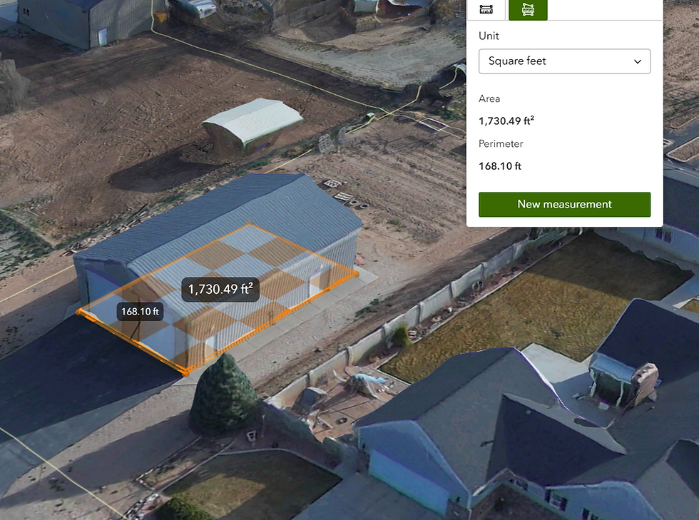
A targeted program can begin with both high-resolution 2D orthomosaic imagery and detailed 3D models.
The orthomosaic provides the familiar top-down GIS view needed for parcel review, mapping, and general assessment workflows.
The 3D environment adds another level of property understanding.
Instead of relying entirely on vertical imagery or a limited set of oblique views, staff can examine structures from different perspectives, better understand building geometry, and perform virtual review and measurement directly from the data.
That creates a dataset designed for actual property analysis—not simply visual reference.
Flexible Acquisition Instead of a Fixed Rotation
Assessment priorities change.
Development moves.
New subdivisions appear.
Different areas enter reappraisal cycles.
Some locations may require imagery again sooner than expected, while others may remain useful for years.
A multi-year imagery program should be able to respond to those changes.
FinBee TAC can structure programs around an annual acreage allocation, allowing the county to determine where acquisition provides the greatest value each year.
A community experiencing rapid development may receive additional attention one year. Another area may become the focus during the next reappraisal cycle. Previously captured areas can be refreshed when imagery age or assessment needs justify returning.
The acquisition strategy follows the assessor's priorities rather than forcing the assessor to follow the imagery schedule.

Designed for Government GIS
Imagery becomes far more valuable when it works inside the systems county staff already use.
FinBee TAC develops deliverables with GIS integration in mind, including workflows built around Esri technology.
High-resolution imagery and derived products can support existing GIS environments, assessment applications, internal mapping workflows, and web-based access.
The objective is not to create another isolated application that staff must learn and maintain.
It is to make high-resolution geospatial information easier to incorporate into the county's existing workflow.
Hosted Access or Greater Data Control
Different counties have different technology and data-management requirements.
Some offices want a managed solution where imagery can be accessed through a hosted environment without maintaining large datasets internally.
Other counties want greater control over the underlying imagery and geospatial products.
FinBee TAC can structure programs around either approach.
Hosted access can simplify deployment and ongoing use, while expanded data ownership options can give counties greater long-term control over the information being produced.
The technology should fit the county—not the other way around.

Build Intelligence on Top of the Imagery
High-quality imagery creates the foundation for additional analysis.
Depending on the needs of the assessor, programs can be expanded with capabilities such as:
AI-assisted building or change-detection layers
Hosted ArcGIS imagery and data services
Additional annual acquisition acreage
Expanded data ownership and delivery options
Derived geospatial products for GIS and assessment workflows
These capabilities can be added where they provide value rather than forcing every county into the same package.

Why Targeted Acquisition Can Make Sense
There will always be situations where countywide imagery is the right solution.
A county may need uniform coverage for emergency management, transportation, public works, planning, GIS, or other departments.
But the needs of the assessor can be different.
If the primary objective is to inspect improvements, verify property characteristics, support measurement, reduce unnecessary field visits, and maintain current information in developed areas, collecting substantially better data over the highest-value acreage may provide more operational benefit than distributing the same budget across every square mile.
That is the idea behind targeted acquisition.
It is not about capturing less simply for the sake of reducing coverage.
It is about putting the highest-quality information where it can do the most work.

We Can Go Big Too
Targeted acquisition does not mean small projects sometimes it means 325,000 acres like Iron County, Utah.
FinBee TAC can scale high-resolution imagery programs across entire cities, incorporated communities, major growth corridors, and large developed areas when the assessment need calls for broader coverage.
For some counties, the best strategy may be to focus on several smaller priority areas. For others, it may make more sense to capture an entire city or a large concentration of developed properties in a single acquisition.
That can include:
Full-city high-resolution imagery
Multiple cities or communities in one program
Large developed corridors and growth areas
High-resolution 2D orthomosaics
Detailed 3D models
GIS-ready delivery
Hosted or county-owned data options
Detection and analysis layers
The key is not limiting the size of the project.
It is matching coverage, resolution, and cost to where the assessor gets the greatest value.
A rural county may not need approximately 1-inch imagery across hundreds of thousands of undeveloped acres, but it may benefit significantly from capturing its largest cities, towns, subdivisions, and growth areas at very high resolution.
Our approach is therefore not:
“Only fly small targeted areas.”
It is:
“Capture the developed areas at the level of detail the job requires.”
Whether that means a few thousand acres around a community or a large citywide acquisition, FinBee TAC can build the program around the assessment need.
High Resolution Where Development Is Concentrated
For assessors, cities and developed areas are often where the greatest concentration of structures, additions, new construction, and property change occurs.
That makes them especially well suited for high-resolution 2D and 3D acquisition.
Target when it makes sense. Scale when the city requires it.

An Imagery Program Should Solve an Assessment Problem
Resolution, artificial intelligence, GIS, 3D modeling, and web technology are all tools.
The real measure of an imagery program is whether it helps the assessor do the job more effectively.
Can staff review more properties remotely?
Can they identify areas that deserve additional investigation?
Can they verify structures and property characteristics?
Can they perform useful measurements from the office?
Can the county direct its imagery budget toward the places where conditions are changing?
Those are the questions FinBee TAC uses to design assessment imagery programs.
Instead of beginning with:
“How do we fly the entire county?”
we begin with:
“Where can better information make the biggest difference?”
Then we build the program around the answer.


Comments